Department of Transport map of South Africa 1959 / via The Heritage Portal
Many people will be travelling back home this Easter weekend and that sparked a thought rabbit hole about how our national roads have changed over my lifetime.
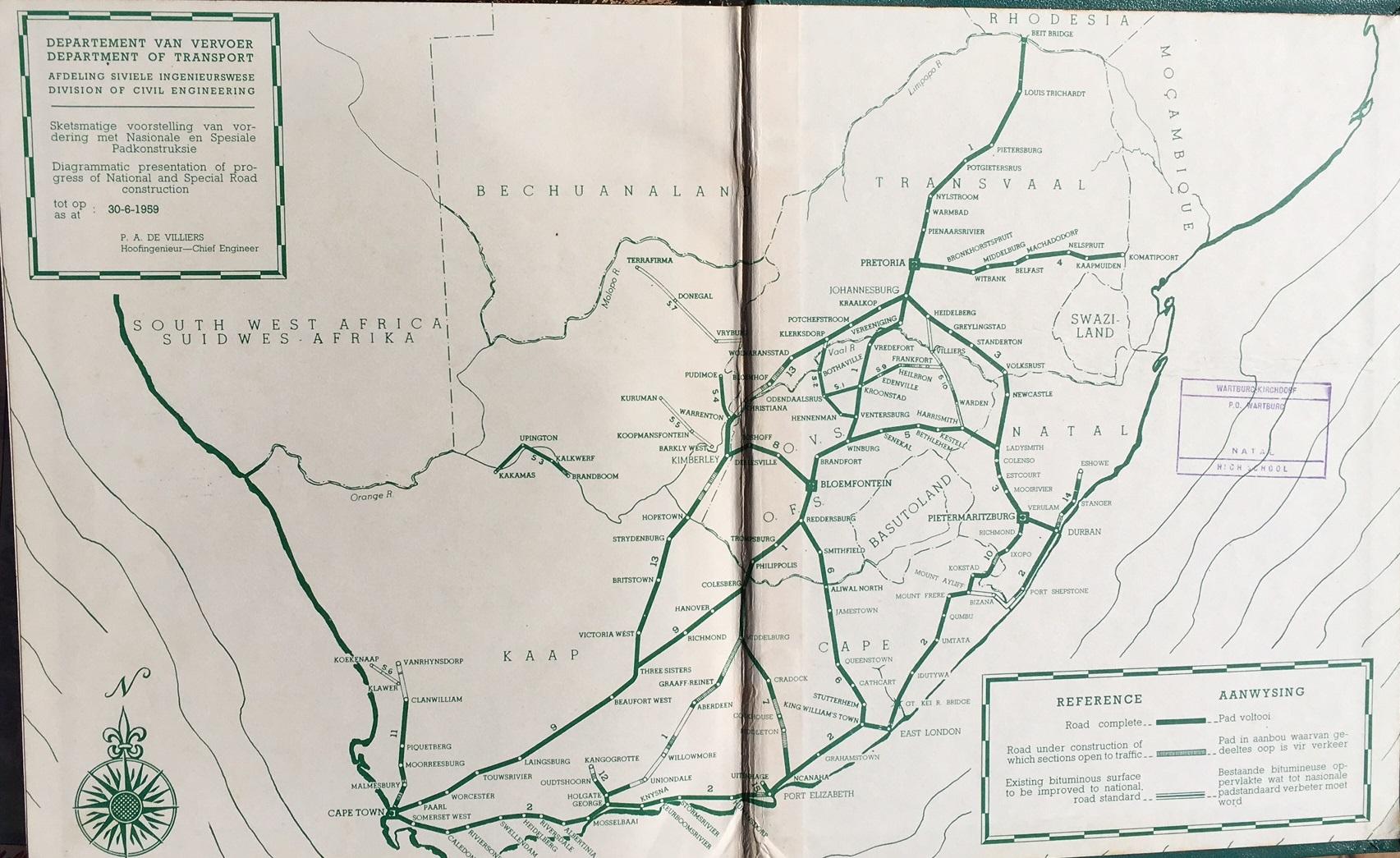
So I went looking and found a Department of Transport map of our national road network from 1959 which confirmed a lot of my childhood memories. Let me go through some of them:
The N2 highway began at Cape Town and ended in Durban . The stretch between Port Shepstone and Mt Ayliff was dodgy though, and I remember my father driving from Durban to East London via the road to Richmond, south of Pietermaritzburg. Today, that road is the R56, but back then, it was the N10.
The freeway north of Durban which is today the Ruth First Highway (M4) was then known as the N14. It terminated at Eshowe. Today, that road has been replaced by extending the N2 around Durban, terminating in Ermelo and making it the longest national road in the country.
Speaking of long roads, after the N14 name was removed from north of Durban, that name is today used for the road linking Pretoria to Springbok in the Northern Cape. That road did not exist when I was a kid. The section of the N14 between Pretoria and the Cradlestone Mall in Gauteng is today a major freeway.
The N3 from Durban to Johannesburg used to route through Ladysmith, Newcastle, Volksrust, Standerton, Greylingstad through to Heidelberg . My father became fond of what he referred to as the “Villiers route” which involved branching left at Ladysmith through Van Reenen’s pass to Harrismith, Warden, Villiers through to Heidelberg. It was living dangerously because Indian South Africans were not allowed in the Orange Free State. Today, the N3 has been rerouted to follow the “Villiers route”. The road from Ladysmith to Volksrust is now called the N11 and branches north from Volksrust through Ermelo, Middelburg, and crosses into Botswana at Groblersbrug.
The N1 linked Johannesburg to Beit Bridge as it still does today, but back then, it did not run south to Cape Town. Instead, the N1 branched east at Colesburg in the Orange Free State down to Middelburg
Today, those roles are swapped. Colesburg to Cape Town is the N1 and Colesburg to George is the N9.
We spoke earlier about the N11. That name originally applied to the road from Cape Town through Malmesbury, Moorreesburg, Piquetberg, and Clanwilliam . Today, that road is called the N7 and extends from Clanwilliam through Springbok crossing the Orange River into Namibia at Vioolsdrif.
The N12 was once a short stretch of road connecting George to Oudtshoorn ending at the Cango Caves. The road from Johannesburg via Potchefstroom, Klerksdorp, and Wolmaransstad through Kimberley was called the N13. which terminated south of Victoria West, joining what was then the N9 near Three Sisters north of Beaufort West. The N12 was subsequently extended from Oudtshoorn to Beaufort West where it briefly shares the N1 before branching left at Three Sisters. The N13 is now the N12 and was extended east of Johannesburg to Witbank (now called Emalahleni).
The N4 linked Pretoria to Komatipoort — the border with Moçambique. That road has now been extended westward too, linking Pretoria to Rustenburg and Zeerust eventually crossing into Botswana at the Skilpadshek border with Botswana.
Yes, I’ve driven all of these routes.